
Forestry
Point Density: 320 points per m^2
Height: 80 m AGL
Speed: 8 m/s
Data Acquisition Time: 7 minutes
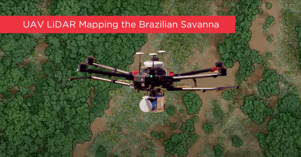
In 2017, an international team of Brazilian and U.S. scientists used two UAVs, including a Phoenix LiDAR system, to monitor and analyze degraded parts of the Brazilian Savanna that had previously been surveyed with aircraft and LiDAR. Their goal: to protect the most biologically diverse savanna in the world from further human impacts, restore native species, and increase CO2 absorption to mitigate the effects of climate change, all while balancing the protection and restoration of natural resources with food production.
UAVs are already used extensively in Brazil for a number of other uses. This team gathered both physical and biological information about the vegetation cover using Phoenix LiDAR and also visual (RGB) sensors. Counting trees is a critical metric that enables them to estimate planted seedling survival rates, species density, plant spacing, etc.
This team’s objective was to demonstrate how both Phoenix LiDAR and RGB sensors helped them monitor the vegetation structure (including tree numbers and height) in the Cerrado savanna. Phoenix LiDAR’s accuracy in performing automated measurements of the number and height of the trees was superior to the RGB sensors, though RGB was also useful for identifying tree species.
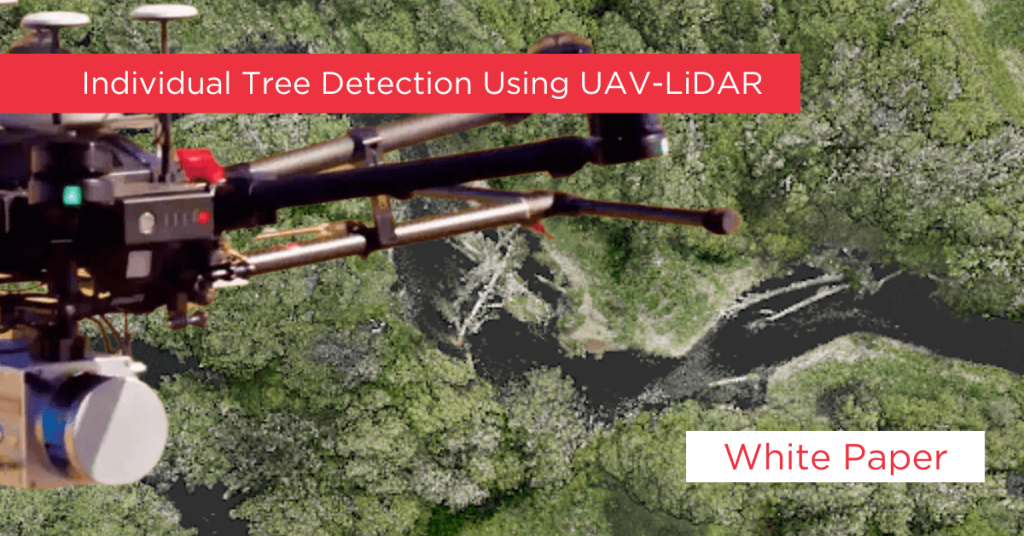
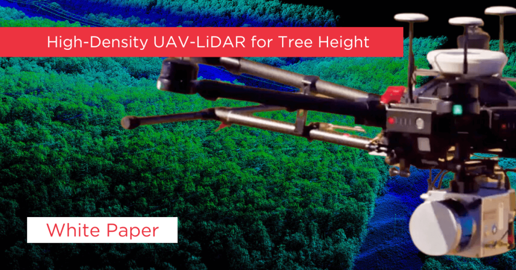
Unmanned Aerial Vehicles (UAVs) have become much more useful due to concurrent technological advancements. Individual tree detection is important to managing forests, but changing from traditional data collection to UAVs to collect this data is daunting due to the huge amount of information available.
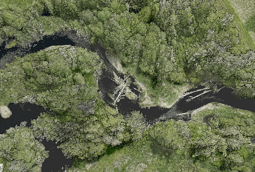
The team of international researchers wrote this article as a tutorial to help non-researchers understand the benefits of using UAVs to do research usually done using airplanes. They break down how to do Individual Tree Detection (ITD) using images and LiDAR maps from UAVs carrying Phoenix Scout LiDAR cameras, and also using open source software to process the data. The software created a canopy height model (CHM) and also performed ITD.
Because this approach is aimed at beginners to remote sensing (using drones to capture data), the methods are simplified and the tree areas studied are relatively easy to study due to relatively open canopies.
Doing this kind of work in a timely manner is important for understanding the forest’s response to climate change. Traditional study methods provide the data, but at a higher financial, time, and labor cost. Especially if there is a lot of forest to monitor. UAVs can provide the data at significant savings to all three costs.
The tutorial uses R studio software and the R programming language.
The size of the first area studied is 11.95 out of approximately 700 hectares of the E.O. Siecke State Forest, East Texas, which is managed by the Texas A&M Forest Service. This aerial imagery was gathered in August 2020 using a DJI Mavic Pro quadcopter, using the
Pix4Dcapture flight planning app.
The size of the second area studied is 23.04 hectares of the Ordway-Swisher Forest Dynamics Plot at the Ordway-Swisher Biological Station in Florida. The station is a long-term research facility by the University of Florida and it is also part of the Global Earth Observation Network
(ForestGEO) (https://forestgeo.si.edu/). The LiDAR data were collected in June 2019 with the
GatorEye Unmanned Flying Laboratory (http://www.gatoreye.org/). This system is composed of a DJI M 600 Pro hexacopter with a Phoenix Scout Ultra core, which has a STIM300 inertial measurement unit (IMU) coupled with a differential GNSS antenna and integrates a Velodyne
Ultra Puck 32c, a 24 MP visual camera, and a Headwall Photonics Nano hyperspectral camera. The data were post-processed using the GatorEye multi-scale post-processing (GMSPP) workflow (v. 229 detailed at http://www.gatoreye.org/).
The tutorial covers the following:
Loading the data
Clipping the area of interest
Classifying ground points
Creating a DTM
Height normalization of the point cloud
Creating a CHM
“Smoothening” the CHM
Detecting the treetops
Assessing accuracy
The goal is to help lay people understand how UAVs can help researchers do their work. Reducing the costs and complexity of this kind of research by using a UAV with a Phoenix Scout Ultra LiDAR camera, instead of an airplane-mounted option, makes this type of research more accessible to other researchers.
An international team of scientists from Brazil and the University of Florida are working together to study urban forests as a means of mitigating climate change. The University of Florida’s Second Generation GatorEye UAV LiDAR system uses a Phoenix Scout Ultra system to provide scientific backing for policies to preserve the forest inventory in the urban landscape.
This team’s objective is to improve what has been a difficult and costly data gathering process by incorporating remote sensing technology, such as UAV LiDAR, and to determine the levels of point density that return the best data. Ultimately, their goal is to increase the amount of research done on a part of the urban landscape that is difficult to research, and to provide decision makers with better information on which to base policy decisions.
This study looked closely at how other studies used LiDAR in similar situations. They found LiDAR is great for measuring tree parameters and designing vegetation structure 3D maps, and it provides spatial and temporal flexibility that other methods don’t offer. The other researchers got high resolution data at significantly lower cost, and also indicated applicability for urban forests using LiDAR alone or integrated with optical images.
LiDAR is more convenient than airborne LiDAR—lower cost, more accessible transportation, higher density of points. UAV LiDAR provides models with higher resolution, even though the value of point density influence for individual tree parameters is still not understood and needs further research.
Based on other studies’ findings, combining field-based research and remote sensing data seems to be best practice, especially if high-resolution LiDAR is available.
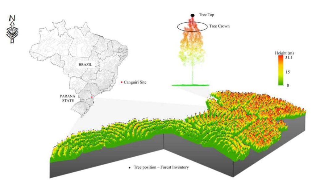
In November 2019, this Brazilian and U.S. team performed a physical measurement of 171 Brazilian pines, including circumference, height, and geographical position, in an urban forest remnant located in Curitiba, State of Parana, southern Brazil. They then collected the same trees’ data using UAV LiDAR and compared the data.
An international team of scientists from the University of Florida (USA), University of São
Paulo (Brazil), Florida A&M University (USA), USDA Forest Service (USA), Federal University of
Paraná (Brazil), University of Maryland (USA), and Bangor University (UK) worked together to
use the University of Florida’s GatorEye unmanned aerial vehicle (UAV) LiDAR system to fight
climate change. The GatorEye system uses Phoenix LiDAR cameras and software to compare
and contrast tree crowns and forest structure over time.
When storms and hurricanes change the forest canopy structure, traditional LiDAR takes too
much time and logistical planning to quickly assess the damage. Phoenix UAV LiDAR can
autonomously and efficiently get high-resolution, quality data from relatively large areas
(hundreds to thousands of hectares) to help decision makers with post-storm recovery.
The team compared aircraft-borne LiDAR surveys of the Apalachicola National Forest, USA with
single-pass GatorEye UAV LiDAR surveys. They found the following:
● Digital Terrain Models (DTM) with less than 1 m differences between airborne and UAV
LiDAR, within a 145 degree field of view.
● Canopy height models (CHM) provided reliable information from the top layer of the
forest, allowing reliable treetop detection, though tree height underestimations occurred
at 175 m from the flightline.
● Crown segmentation was reliable only within a narrower field of view, from which the
shadowing effect made it unviable.
Because UAV LiDAR is limited by onboard battery capacity, this group is researching efficient
sampling methods using single-pass surveys that focus on samples of specific locations only.
Despite the limitations, UAV LiDAR systems cost less and are more flexible, enabling rapid
planning and response, as well as more frequent data collection and higher point density data.
Single-pass surveying has not been studied for airborne LiDAR, but using LiDAR for monitoring
forest health is well studied. Airborne LiDAR data is highly dependent on the flightline, which
determines pulse density and usually includes overlapping. Phoenix UAV LiDAR is more
efficient with a single pass, but closer to the objects being surveyed, mitigating the difference in
density. Scan angle makes a large difference, and further research is required to determine
accuracy based on scan angle.
This study included sample areas in the Apalachicola National Forest, public land in the sandhills of the Florida Panhandle that covers approximately 233,000 hectares.
A team of scientists from the Department of Forestry, the University of Brasilia, and other organizations invested in the study of climate change have been using sensors from Phoenix LiDAR Systems to map vegetation biomass by drone, providing key insights into the carbon cycle to help lower carbon emissions and better manage the impacts of climate change.
[Vegetation biomass is the total weight or quantity of plants present in a given area—terms like yield, plant matter, and plant production are also sometimes used in place of biomass.]
Traditionally, scientists collect vegetation biomass data in the field by walking through a sample area and making measurements. These sample measurements can then be extrapolated using mathematical models to create measurements for the entire environment. But this manual approach is incredibly time-consuming and expensive, not to mention potentially bad for the environment, since it requires researchers to walk through the area on foot as they collect data.
To solve the data collection problem, scientists have honed a new approach: using drones equipped with LiDAR sensors.
By using UAVs (Uncrewed Aerial Vehicles, also known as drones), researchers can fly over sample areas and collect detailed LiDAR data in a fraction of the time it would take to do so manually. This data can then be processed using mathematical models to estimate the total biomass for the entire system.
The UAV LiDAR approach has several benefits, including:
- Speed. The approach is much faster than mapping and making vegetation biomass estimates via manual data collection.
- Accuracy. Using drone LiDAR data instead of manually-collected data improves the accuracy of outputs such as tree height, leaf area density, and—the key data point—biomass.
- It’s better for the environment. This approach also minimizes the negative impact data collection can have on the environment, since the drone flies above the vegetation, avoiding the need for people to walk through it on the ground.
So far, the UAV LiDAR approach to mapping vegetation and making biomass estimates has primarily been used in forests, focusing solely on the biomass of trees. But there are other important types of ecosystems that contribute to the planet’s carbon cycles, such as the tropical savanna found in Brazil, called the Cerrado.
The Cerrado is the second largest habitat in South America, and a crucial environment for the global carbon cycle. The team of scientists decided to test UAV LiDAR there for vegetation mapping and biomass calculation, presenting one of the first times the approach has ever been used to study a tropical savanna habitat.
Keep reading to learn how the team adapted its UAV LiDAR data collection methods for the unique environments found in the tropical savanna, and whether the approach was a success.
Why Mapping the Savanna Is So Important
Although rain forests are often the focus when we talk about carbon capture and climate change, tropical savannas make up 20% of the Earth’s surface and also play a key role in the carbon cycle.
In recent years, these savannas have lost a huge amount of vegetation due to human encroachment and increases in fires caused by climate change. In Brazil, for example, the Cerrado has lost almost half of its original vegetation over the last few decades alone, a loss that can primarily be attributed to the growth in agricultural production in the area.
Although previous studies have highlighted the benefits of using UAV LiDAR for estimating biomass in forests by focusing on trees, most of the biomass in tropical savannas comes from things like grass, dead leaves, and plant material on the ground, all of which can have a big impact on the amount of carbon stored in the ecosystem.
To inform policymakers in developing strategies for carbon markets, it’s important to understand how the environment naturally captures and stores carbon, and how much of this is happening in different types of environments across the planet.
This information is crucial for reducing carbon emissions—and that’s why mapping the vegetation biomass in the Cerrado was a point of focus for the team of scientists. If they could develop an approach that worked there it could potentially be applied to other tropical savannas, presenting a major step forward in humanity’s understanding of the global carbon cycle.
How Scientists Used UAV LiDAR to Map the Cerrado
Scientists had already established a method for mapping large areas of forests using UAV LiDAR. The approach involved collecting data in a sample area by drone, then using mathematical models to extrapolate the biomass for the entire environment. But the Cerrado presented a new environment, which meant new models would have to be developed.
The end goal for the team was to estimate and map the total aboveground biomass density (AGBt) of woody, shrubs, and surface vegetation found in the Brazilian savanna—an ambitious endeavor given that the Cerrado spans over two million square kilometers.
Here is the approach they planned to use:
- Identify types of vegetation for mapping. Three major types of vegetation were identified in the tropical savanna: forest, savanna, and grassland.
- Develop a framework. Given that this type of environment hadn’t been mapped with UAV LiDAR before, new frameworks were needed that would allow the scientists to choose the best UAV-LiDAR metrics for building AGBt models.
- Identify areas for data collection. Four locations in the Cerrado biome were selected for data collection, each of which had unique vegetation structures and was representative of different types of vegetation found there in terms of height, width, and species diversity.
- Take measurements. Using UAV LiDAR, scientists would collect measurements at each of the four locations.
- Process the data and make conclusions. After collecting the data, scientists planned to process it using the frameworks and models they had developed. They hoped to make findings regarding the vegetation biomass in the Cerrado, as well as evaluate the UAV LiDAR approach itself to see if it could be used to map other tropical savannas.
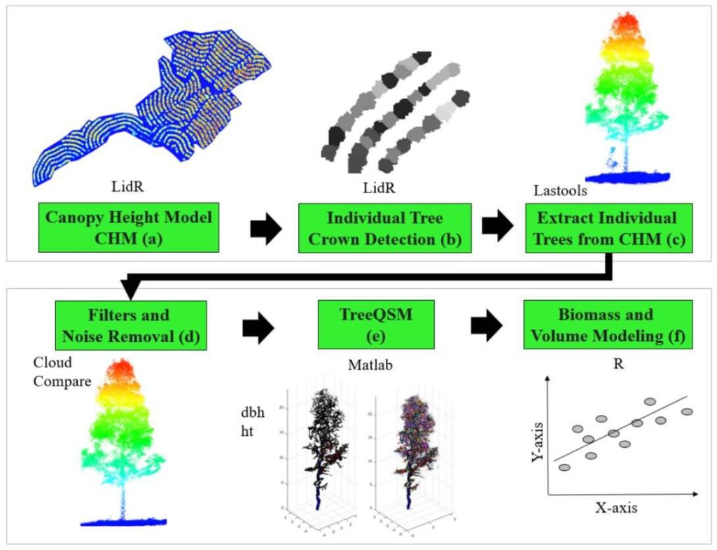
Individual tree attributes, such as stem volume and biomass, are usually predicted by using traditional field-derived allometric models. However, these models are derived from data collected from small areas and lack a level of detail of tree components (e.g., stem, branches, and leaves). Remote sensing techniques such as the Quantitative Structure Modelling (QSM) applied on
high-density LiDAR data emerge as a promising solution for obtaining extensive and detailed tree attribute estimates. We used a high-density LiDAR data on board of a Unmanned Aerial Vehicle (UAV) to evaluate the performance of the QSM approach in estimating field-derived individual tree attributes such as the diameter at breast height (dbh), tree height (ht), and volume (v), as well as the stem (SAGB), branch (BAGB), and total (TAGB) aboveground biomass of eucalyptus trees. QSM was used in two different approaches: (i) using dbh and h derived from QSM and then applied into the field-based equations for estimation of volume and (ii) deriving tree volume directly from QSM. In general, all fitted models using the QSM approach were satisfactory, but with a slight tendency of over-estimation of dbh (9.33%), ht (12.40%), v-QSM1 (26.35%), v-QSM2 (26.66%), TAGB (27.08%), SAGB (25.57%), and BAGB (20.08%). Non-significant differences were noticed when estimating the dbh, tree volume, stem, and aboveground biomass. Despite the overestimation, this study indicates that using the QSM approach to estimate individual tree attributes from UAV-LiDAR is a promising alternative to support the decision-making process regarding forest management activities, especially when considering tree architecture and biomass components.
Forest plantation area is constantly increasing across the globe, and the goods and services provided by these forests are becoming tremendously diverse. In this context, Brazilian forest plantations stand out with a prominent position, in which more than 10 million ha supply industries of pulp and paper, fuelwood, and solid wood products. Brazilian forest industries demand millions of cubic meters of wood annually. Thus, fast and reliable information regarding stand structure and wood availability is crucial to ensure industrial demand.
Eucalypt stands are the most important source of short fiber pulp, fuelwood, and charcoal due to their fast growth and wood properties. Usually, fast-growing eucalypt plantations are grown in monoculture. There is, however, a recent increase in crop-livestock-forest system area. Eucalyptus trees established in crop-live-stock-forest systems are usually planted in rows, presenting lower stand density and diverse canopy structures. Consequently, defining sampling strategies for these trees becomes a challenging endeavor, resulting in a lack of literature-review based recommendations. Forest inventories are considered an essential source of quantitative and qualitative information for the management of forest resources. However, the traditional methods are considered complex and laborious activities, and remote sensing methods have emerged as auxiliary tools for attaining fast and reliable data. In, the authors highlighted the main technologies for remote sensing-assisted forest inventories, and Light Detection and Ranging (LiDAR) was listed as a major player. [register below to download full whitepaper]
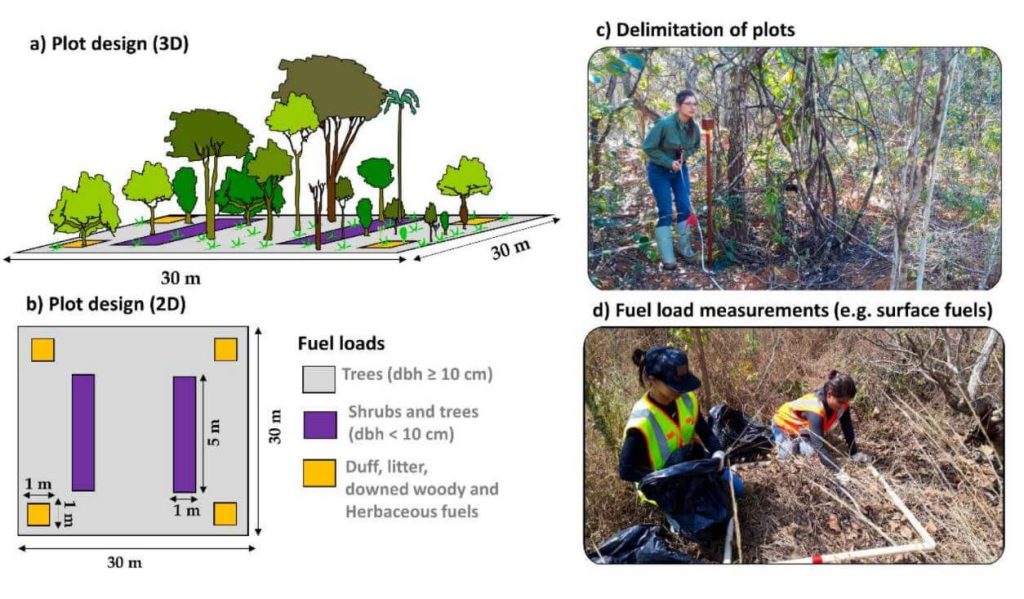
Quantifying fuel load over large areas is essential to support integrated fire management initiatives in fire-prone regions to preserve carbon stock, biodiversity and ecosystem functioning. It also allows a better understanding of global climate regulation as a potential carbon sink or source. Large area assessments usually require data from spaceborne remote sensors, but most of them cannot measure the vertical variability of vegetation structure, which is required for accurately measuring fuel loads and defining management interventions. The recently launched NASA’s Global Ecosystem Dynamics Investigation (GEDI) full-waveform lidar sensor holds potential to meet this demand. However, its capability for estimating fuel load has yet not been evaluated. In this study, we developed a novel framework and tested machine learning models for predicting multi-layer fuel load in the Brazilian tropical savanna (i.e., Cerrado biome) using GEDI data. First, lidar data were collected using an unnamed aerial vehicle (UAV). The flights were conducted, over selected sample plots in distinct Cerrado vegetation formations (i.e., grassland, savanna, forest) where field measurements were conducted to determine the load of surface, herbaceous, shrubs and small trees, woody fuels and the total fuel load. Subsequently, GEDI-like full-waveforms were simulated from the high-density UAV-lidar 3-D point clouds from which vegetation structure metrics were calculated and correlated to field-derived fuel load components using Random Forest models. From these models, we generate fuel load maps for the entire Cerrado using all on- orbit available GEDI data. Overall, the models had better performance for woody fuels and total fuel loads (R2 = 0.88 and 0.71, respectively). For components at the lower stratum, models had moderate to low performance (R2 between 0.15 and 0.46) but still showed reliable results. The presented framework can be extended to other fire-prone regions where accurate measurements of fuel components are needed. We hope this study will contribute to the expansion of spaceborne lidar applications for integrated fire management activities and supporting carbon monitoring initiatives in tropical savannas worldwide.